Mountain Biking Bend, Oregon: Funner & Tiddlywinks
If you're following my Instagram, you might have seen that Greyson and I were in Oregon last week. We drove up from Truckee and my parents drove down from eastern Washington, and we met in the middle! Our first destination was Bend, Oregon, one of my favorite towns. It's got climbing, hiking, river floating, amazing beer, and awesome restaurants. It's also known as a popular mountain biking location, and Greyson and I have ridden there a couple times before, checking out a section of the Deschutes River Trail and riding a bit in the Phil's Trail network. While I had fun riding on those trails, they didn't seem "mountain bike destination" quality, and I wanted to check out the best of what Bend has to offer.

Mountain Biking Bend Oregon // tahoefabulous.com
From our research (internet based and talking to the super friendly staff at Crow's Feet Commons), riding up Funner and down Tiddlywinks was the most highly recommended. The trailhead was pretty easy to find - we followed directions from MTB Project to the parking area at the green gate, located here, about 9 miles from downtown Bend.
Mountain Biking Bend // tahoefabulous.com
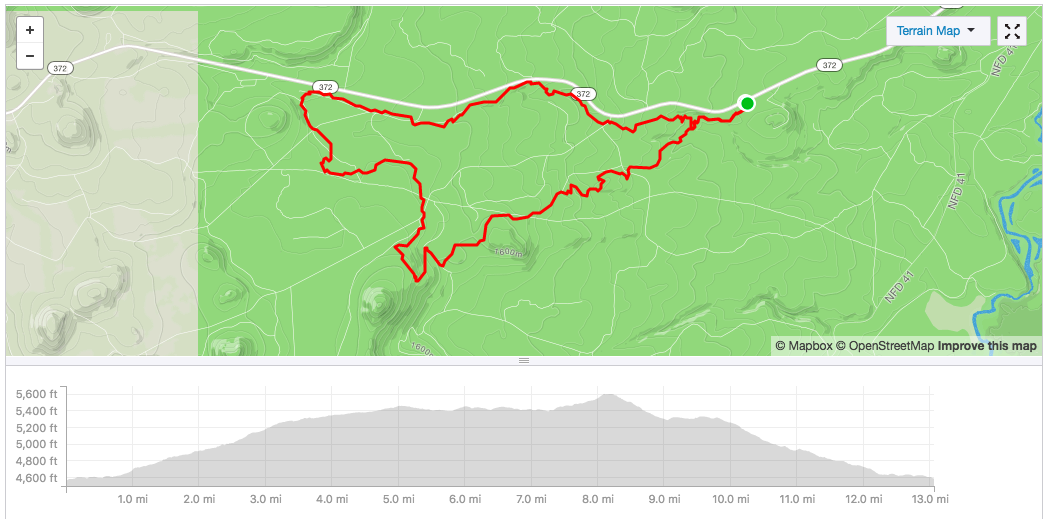
From the parking lot, we headed up on Storm King, which we only rode a small section of. After about 0.7 miles, the trail forked and we took a sharp right on to Funner. Funner has sections that are two way, and parts that are split into uphill and downhill only. Those are clearly marked, and it's important to stay on the correct side, as people come bombing down the downhill sections, not expecting to see someone climbing up. The climb from the gate to the top of Funner (including the Storm King Section) is about 5 miles and 1,000 feet of climbing. It's never super steep on the climb, but it can be sandy and leg sapping and there are very few breaks from the uphill grind. The trail is rated as intermediate, but it followed a trend I noticed in lots of the trails I've ridden in Bend - long, long stretches of easy riding, punctuated by very occasional volcanic rock gardens that are difficult-to-impossible for me to ride.
At mile 5, we hit the top of Funner and a parking lot. From here, the start of Upper Tiddlywinks isn't super obvious but isn't too hard to find. The first part of Tiddlywinks is a fun mix of bermed downhill stretches, short punchy climbs, and flat-ish rock gardens. That goes for about 1.1 miles, and then we started to climb again. We climbed about 200 feet in 0.8 miles, but at that point the climb felt pretty rough after so much time in the saddle climbing. Even though none of the climbing was very steep, 8 miles of riding that was mostly climbing or flat really wore me out!
With that, we were finally at the top and ready to descend Lower Tiddlywinks. The trail immediately launches into big, bermed corners, table top jumps and other man made features, with a few natural rock drops built in. I had a blast on the trail - it reminded me a lot of Freund Canyon in Leavenworth with the style of trail building. As for difficulty, all of the tabletops and rock features are rollable, though it's a great trail for practicing getting some air. There are a few doubles and more complicated features, but everything has a very obvious ride around. We descended ~1,100 feet in just over four miles, and I had a smile on my face the whole time. At mile 12.3, we hit the intersection with Storm King and headed back to the car. Total, we rode just over 13 miles with almost 1,400 feet of climbing and a moving time of 2:12.

Mountain Biking Bend // tahoefabulous.com
I had a great time on Tiddlywinks and it was absolutely worth the climb up - this is the kind of riding I was hoping for in Bend. Additionally, the trails are very well maintained and very well marked. The only thing that was a little confusing to me at first were "Y" marker signs when the trail split. We figured out that this meant the fork was going to come back together soon, and often the "Y" sign delineated an easier and harder route for that short section. If you're an intermediate or higher rider, I'd highly recommend this route. I think it would be doable for a more advanced beginner, but you'd have to walk quite a few sections and the downhill part might not be worth the climb to the top. If you're more on the beginner side, I'd recommend Ben's Trail in the Phil's Network or the Deschutes River Trail for scenery.
Trail Stats
Location: Wanoga Trails, Bend, Oregon
Mileage: 13 miles
Elevation Gain: 1,390 feet
Difficulty: Intermediate
See my Strava route here.