Three Awesome Mountain Bike Routes in Tahoe Donner
Tahoe Donner is the largest neighborhood in Truckee, full of second homes and vacation rentals on a ridgeline north of Donner Lake. It’s big enough that it has a golf course, rec center, forestry department, and a bunch of awesome mountain bike trails. While you can access the trails of Tahoe Donner from a few different trailheads around town, I’m highlighting three fun routes that all begin at the Alder Creek Adventure Center. Note: unless you are living, visiting, or staying at a rental in Tahoe Donner, park on the road outside of the fence where there’s usually plenty of parking.
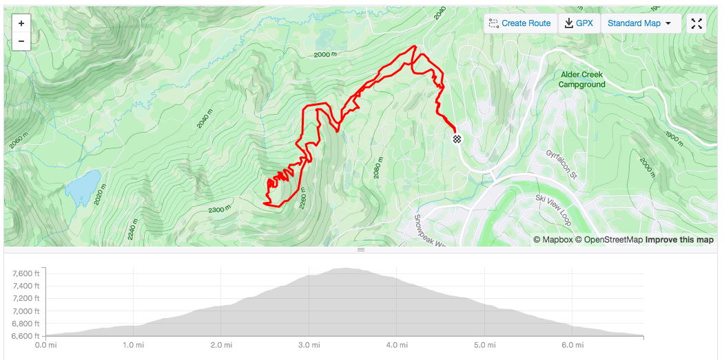
Hawkes Peak Loop
Hawkes Peak Loop // tahoefabulous.com
This is the most challenging loop I’ve ridden in Tahoe Donner. It’s got great views, a section with more technical downhill than most of Tahoe Donner, and a super fun descent with lots of great little rock rolls and jumps. All of these routes begin with the same first few trails: Alder Creek Northern Terminus (0.34 miles) to Randy’s Ramble (0.33 miles) to Cinnamon Twist Connector (<0.1 miles) to Cinnamon Twist Upper. These first few segments aren’t well signed, so it’s nice to have the Trailforks app on your phone, but it’s also hard to get too lost, because eventually you’ll pop out on a fire road (or at least I always have) Once on Cinnamon Twist Upper, you’ll follow that for about 0.24 miles until it crosses the Sundance fire road where you’ll turn left and start the long climb up.
After about 0.3 miles on Sundance, the trail will fork and you’ll keep left to stay on Sundance until it splits at about 0.7 miles in, where the fire road crosses True Grit trail. Take the right turn on to Crazy Horse fire road for a 0.5 mile, steep climb before taking the right fork and continuing the steep fire road climbing on Andromeda fire road. (I definitely got off to push at a couple of the steep parts of this fire road climb and got very jealous of the group that passed us on E-Bikes.) After about 0.5 miles on Andromeda, the climb flattens out and you’ll bend right around the shoulder of Hawkes Peak. Keep a look out for a singletrack trail to your right at about 0.6 miles.

Hawkes Peak Loop // tahoefabulous.com
Hawk’s Peak (Upper Section) is the last bit of climbing. I ended up pushing up some of this 0.28 mile section too; it’s not overly technical, but I was tired! You’ll be rewarded with a summit and an incredible 360 degree view of Truckee. It’s (literally) all downhill from here! The first and most technical downhill segment is Mother Lode (Upper Section). I’ve ridden quite a few trails in Tahoe Donner, and I generally think that the trails are easier than their rating on Trailforks. This one is an exception, or at least it was when I rode it in early August of 2020. The trail was dry and loose with off camber turns and chunky rocks. For this loop, you won’t ride all of upper Mother Lode. At about 0.9 miles in, take a hard right onto the very short True Grit/Mother Lode Connector, which will dump you out onto True Grit (Upper Section).
While I enjoyed the views from the top and the challenge of Mother Lode, True Grit was when I really started having fun. Even though the trail was still loose and dusty, this part was holding together a bit better and it was fun and flowy. Trailforks separates True Grit into two segments, splitting them where it crosses the Sundance fire road, but while you’re riding it, it really doesn’t feel like two different trails, even though they have different difficulty grades. True Grit (Lower Section) starts at about 0.75 miles in. My favorite part of True Grit is the little features sprinkled throughout - rock rolls, small jumps, etc. They all have ride arounds if you’re not interested in features, but if you made it down Mother Lode, you can definitely handle all the features. The lower part of True Grit ends after about 0.85 miles at Alder Creek Road. Here, you can ride Alder Creek Road back to the parking area or (if you want a bit more time on the trails) ride about 0.15 miles before turning right onto Pony Express fire road for about 0.39 miles and getting back onto Alder Creek Northern Terminus.
Watch my video of Mother Lode and True Grit here.
Trail Stats
Distance: 6.8 miles
Elevation Gain: 1,069 feet
Difficulty: Advanced
True Grit Up & Mother Lode Down

True Grit Mother Lode // tahoefabulous.com
This route is less technical than the previous one, and it avoids the steep fire road climb for a challenging but doable singletrack climb. This route also startsAlder Creek Northern Terminus (0.34 miles) to Randy’s Ramble (0.33 miles) to Cinnamon Twist Connector (<0.1 miles) to Cinnamon Twist Upper. On this route, you’ll only be on Cinnamon Twist Upper for 0.1 miles before it crosses True Grit (Lower Section)where you’ll turn left and start the real climb. After about 0.7 miles, the trail crosses a fire road and turns into True Grit (Upper Section)which climbs for another 0.75 miles before ending at another fire road. Go straight onto the <0.1 mile True Grit/Mother Lode Connectorwhich is the last bit of climbing before the intersection with Mother Lode.

True Grit Mother Lode // tahoefabulous.com
Turn right to start going down Mother Lode (Upper Section). This trail section is rated as advanced, but I think that’s mainly due to the top half and the part you’ll ride on this route is more of a challenging intermediate. It’s got great views, but feels a little exposed and the rocks are a little chattery. After about 0.25 miles, the trail becomes Mother Lode (Middle Section) for about 0.4 miles before it dead ends on Hastings, which is a fire road turned double track. Turn left, and after <0.1 miles, the double track turns into Mother Lode (Lower Section). The lower section of Mother Lode is bermed and flowy so it can get pretty loose and dusty in the late summer, but some fun rooty areas and twisty sections. At about 0.8 into lower Mother Lode, there’s an intersection with a trail called Fool’s Gold - don’t take this. Keep going and just before the 1 mile mark, lower Mother Lode turns into Hidden Gem at the crossing with a fire road, which is a pretty similar type of riding.
Hidden Gem ends at South Eur Valley Road at 1.1 miles where you’ll turn right and gently climb for about 1 mile. Keep a look out for a trail on your right - Cinnamon Twist Upper. Climb back up Cinnamon Twist and retrace your ride on Cinnamon Twist Connector, Randy’s Ramble, and Alder Creek Northern Terminus back to your car.
Trail Stats
Distance: 8.4 miles
Elevation Gain: 1,032 feet
Difficulty: Intermediate
Mustang Sally

Mustang Sally // tahoefabulous.com
Mustang Sally is considered one of the best trails in Tahoe Donner and I definitely agree. While it’s rated as advanced on Trailforks, I think that’s a bit of an overstatement and is really more of a challenging intermediate with no mandatory features, steep drops, or difficult rock gardens. Again, start on Alder Creek Northern Terminus (0.34 miles) to Randy’s Ramble (0.33 miles) to Cinnamon Twist Connector (<0.1 miles) to Cinnamon Twist Upper. This time, you’ll ride the full 0.65 miles down Cinnamon Twist Upper to South Eur Valley Road. Turn left and look for Cinnamon Twist Lower at about 0.2 miles.
Cinnamon Twist will end at about 0.37 miles at Alder Creek Road. Continue straight and after about 0.3 miles, East Mustang Sally trail will be on your left. (Don’t turn onto the first trail you see on your left at about 0.2 miles, Mustang Sally has a trail sign.) East Mustang Sally is the main climb on this route - you’ll gain ~680 feet in under two miles. There’s a bit of a false summit at about 1.65 miles though. I was very disappointed to realize that I had more to climb after a short downhill! The actual top of the route has some cool big boulders and a nice view.

Mustang Sally // tahoefabulous.com
You’ll go a bit downhill on East Mustang Sally before you pop out on a fire road. Make a sharp left after a swing right to get on the real downhill, West Mustang Sally. This part of Mustang Sally drops ~540 feet in just under a mile, and like I mentioned earlier, it’s very rideable and fun. It dead ends at another singletrack, Sidewinder, which is about 1.25 miles of rolling hills and a couple of punchy climbs. Sidewinder dumps you back out on Alder Creek Road, and from there you’ll just retrace your ride: Cinnamon Twist Lower to South Eur Valley Road to Cinnamon Twist Upper to Randy’s Ramble to Alder Creek Northern Terminus.
Click here to watch my video of Mustang Sally.
Trail Stats
Distance: 9.7 miles
Elevation Gain: 1,080
Difficulty: Intermediate